


MAPinr - KML/KMZ/OFFLINE/GIS


MAPinr - KML/KMZ/OFFLINE/GIS介绍
感谢您使用 Mapinr。 Android版本的生命周期越来越快,使得非营利项目难以生存。尽管如此,我们将保持这个项目的活力,并遵循我们的愿景,提供一个安全、隐私友好且价格实惠的应用程序。
我们认识到 G 需要最低 Android 版本,但许多设备不支持。我们在我们的网站上提供 Play 商店不再支持的以前 Android 版本(Android 14 以下)的下载。
您想查看和管理自己的兴趣点吗?您是否正在寻找一款可以将您的照片放在地图上的应用程序?
MAPinr 是一款简单(无广告)的 Android 应用程序,可让您管理 kml/kmz 文件并在不同的地图上显示 gpx 文件。 MApinr 非常适合专业用途,也适合远足、骑自行车、跑步、滑雪等。
请让我们知道您的问题和关于如何改进 MApinr 的想法 (mapinr@farming.software)。不要因为我们没有提供您正在寻找的某些功能而表现得粗鲁。相反,请给我们发送电子邮件,告知您的想法和建议。我们知道软件错误可能会非常令人沮丧。请耐心等待,并接受我们有限的资源不允许我们实施所有建议。
MApinr 提供以下功能:
1.无广告/无广告
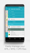
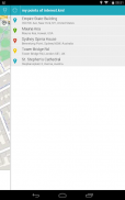
2.管理多个kml/kmz/gpx文件的分层文件夹结构
3. 创建、加载、编辑、保存、导入、导出和共享kml/kmz文件
4. 创建、加载、编辑、保存、导入、导出和共享航点、线路/轨迹和多边形
5. 将图片添加到您的航点(以创建照片地图)
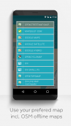
6. 在不同地图上显示航路点、线路/轨迹和多边形(Maps、Satellite、Hybrid、OpenStreetMap、Opentopomap、Opencyclemap)
7. 共享航点坐标
8. 单独为航路点、线条/轨迹和多边形着色
9. 在其他应用程序中打开导出的kml/kmz文件
10. 按名称、地址和坐标搜索
11.位置分享,让你的朋友知道你在哪里
12.同时显示多个kml/kmz/gpx文件
13.合并kml/kmz文件
14.云集成
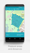
15. 测量地图上的距离和面积
16. 多语言(目前为英语、西班牙语、立陶宛语、波兰语)
扩展功能(通过 LInkedIN 上的捐赠或类似方式免费;在“设置”中激活):
1.免费下载地图/离线地图(openstreetmap)
2.GPX查看器(只能显示GPX文件!)
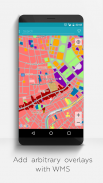
3. 使用网络地图服务(WMS)显示任意地图数据,例如来自 www.data.gov 的 Opendata
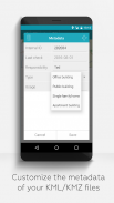
4. 创建自定义元数据
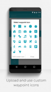
5.上传并使用自定义图标
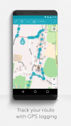
6.记录GPS轨迹
与相关应用程序相比,MAPinr 不会嗅探您的私人数据,甚至不会出售它。请注意,捐款是免费捐款,用于支持我们的非营利工作。


MAPinr - KML/KMZ/OFFLINE/GIS - APK信息
APK版本: 4.1.9程序包: at.xylem.mapinMAPinr - KML/KMZ/OFFLINE/GIS的最新版本
其他版本


同类应用


